The Forever Young Couloir of Rogers Pass… I’ve been dreaming of this one for some time by now. Likely named after the famous Alphaville song, it’s literally an earthly ass-crack, scissoring a mountain in half. Looking at it from the entrance, I was stunned by the towering walls bordering the line, its narrow width, and its ideal 40-degree incline. That put it high up on the bucket list. And don’t get me started on the ultra-scenic approach up the Illecillewaet Glacier granting views of remote valleys that only a few select souls have explored. It’s not solely about the line, more so about the adventure that entails. The original plan was to complete the Youngs Peak Traverse, a huge day by Rogers Pass standards. Along the way, we decided against summiting to drop the couloir instead. Reason: it simply looked too good!
Related: Dome Col Traverse: Glacier Skiing At Its Finest
Report from December 11, 2020
Freddy, Joe, and I rolled into the Illecillewaet parking lot at 8 AM armed with several cups of coffee and far too much stoke. With caffeine coursing through our veins, we speed through the gentle grade leading to the Meeting of the Waters. There’s some history here. Steam engines used to power through the mountains on that very grade.
Old Railroad Grade History
We then took the Sir Donald trail (now buried in a whole lot of snow) and traversed under the Practice Slopes, a group of slidepaths that span from the base of the Overlook, adjacent to Uto Peak. Once we emerged out of tree cover into the first slidepath, we caught a glimpse of our ascent route. We strategically choose to ascend the moraines below the Illecillewaet Glacier on the east bank of the river. Commonly, backcountry skiers prefer to skin up the west bank below the Glacier Crest East Bowl, a route best traveled on a deep snowpack. We thought things were looking a little thin in the alpine so we opted for the former route, the east bank below Mt Sir Donald. In retrospect, that was a mistake, costing time, and increasing our exposure to the overhead avalanche hazard!

Our erroneous route took us through a sketchy blend of icicle-ridden waterfalls, narrow gullies, and giant pillow fields. I’m thinking of overhead hazards, terrain traps, and steep, unsupported terrain. Pretty much all the things backcountry skiers would want to avoid. If it wasn’t enough, the katabatic winds, produced by the glacier cooling overnight, had formed a widespread 5-10cm wind slab on the surface. I noticed it as I was crossing over an exposed pillow. Its slabby top layer fractured right under my downhill ski, almost dragging me into the gully below. Close call… lesson learned! To say the truth, the wind slabs didn’t scare me one bit – they were thin. However, the exposure below did, something that can be minimized through better terrain choice. All in all, stay away from this route if you’re looking to get to the top of the Forever Young Couloir. I live to tell the tale but some may not.

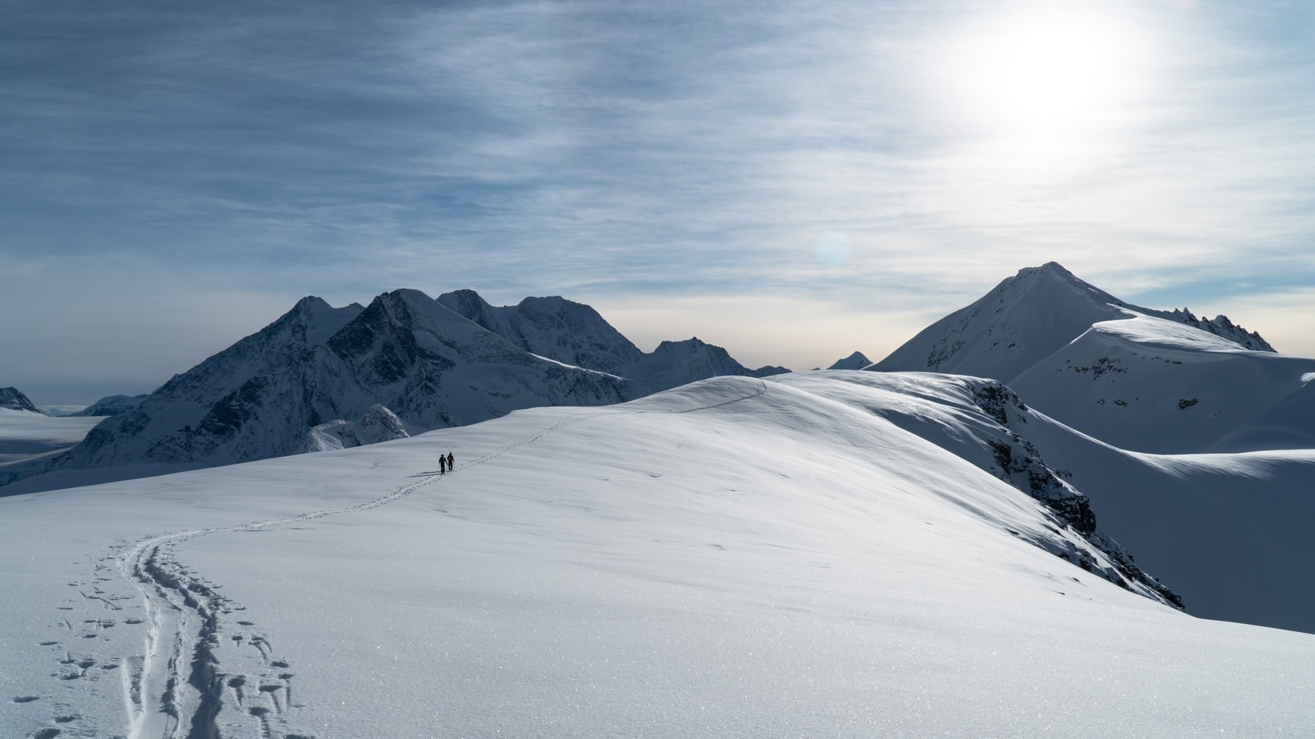
After more than two hours of meandering, we gained the top of the moraines. We were now right below the Illecillewaet Glacier, glaring back at us with its ice-cold hue. Such a stunning glacial landscape spotted with blue ice that may one day be entirely different. Glacial retreat is our harsh predicament. We pressed on through the alpine expanse, trying to make up the time spent navigating the terrain below.

Until then, we had broken trail for most of the way, punching through hard wind slabs. Naturally, we felt an overwhelming wave of fatigue coming though but the fight wasn’t over. The remaining climb to the glacial toe was arduous at best as well as exposed in places. The icy breeze barreling downslope didn’t help. Oh, was it frigid! Such is the price to pay for a bluebird day in December. I felt a great sense of relief after I had borrowed a pristine uptrack that ramped onto the glacier. Progress was much faster.

From the bottom of the pitch below the glacier, it took 45 minutes to gain the icefield. We paused for a few minutes as the sunlight struck our weathered skin. After spending close to three hours in the cold, this felt better than jumping in a hot shower. From here on, navigation on the Illecillewaet Icefield was pretty straight-forward. Just point your skis in the right direction, and walk. One step after another. Side note: we also choose not to rope up on the glacier. It was covered with about 2.5m of snow and not too heavily crevassed. This is typical of the Illecillewaet in December.


We covered the remaining distance at an impressive pace. The nearly flat landscape made it a breeze. Looking to my right, I saw skiers approaching the top of the Ravens, an awesome run set up on a planar slope terminating at the Asulkan Brook. We continued past Lookout Mountain on our way to the Forever Young Couloir, located a short distance prior to the summit of Youngs Peak.

We followed the wind-battered ridge defined the Asulkan Valley’s eastern border, making sure we weren’t too close to its edge. A fall here would be fatal. looking out SE, our advantageous perch granted us a panoramic view of the valleys bordering the Glacier Circle Cabin, far into the remote confines of Glacier National Park. I had only heard of those mystical valleys. I was utterly STOKED. My mind was instantly flooded with trip plans, both on skis and on foot. So many possibilities, I can’t deal with it!

After a skin-skiing down a rather steep slope, we arrived at the entrance of the Forever Young Couloir. While our original plan was to summit Youngs Peak, we settled for the couloir. Apart from a couple of tracks, conditions seemed prime. We dug a test pit representative of the slope we were about to ski. With favorable results, we dropped the line. Steep, narrow, and daunting, a whole more daunting than expected given the difficult conditions.


What seemed like a fluffy blank canvas was closer to a thin, white icing. 10cm of low-density snow laid on top of an ice-hard crust, formed by strong winds and a lasting temperature inversion. Skiing was very possible but super technical given the icy bed surface, exposed rocks, and fast sluff. I cautiously jump-turned my way down, Chamonix style. A word of advice: wait for the right conditions. Plenty of snow and good stability is needed. The alpine winds typically form slabs at the top that may be triggered as skiers drop into the couloir.

After a minute to rest my tired legs, we proceeded down the Asulkan Valley cutting high into the Tree Triangle, a forested cone spanning from the Asulkan Cabin. We skied some trees, pillows, and gullies. I have no shame admitting I fell in a creek and spent 10 minutes scrapping ice off my bases. We slogged out of the valley and slouched into my CRV. Such a blast of a day!

Here’s a lesson. Terrain doesn’t necessarily dictate the difficulty of a line. The snowpack pulls its weight too in deciding whether a route is easy or hard. This couloir in good snow is a dream to ski. Today was the complete opposite. Either way, we’d done it.

I added the couloir to my logbook, only waiting to get back up there when it’ll be in better shape. Up next is the Youngs Traverse. I can’t wait to get this one checked off!
Statistics
| Peak Elevation | 2660m |
| Vertical Gain/Loss | 1600m |
| Distance Traveled | 18km |
| Duration | 7h |
For more beta on my adventures, check out the Route Map. This online map interface is a repository of my ski touring and mountaineering adventures. Simply follow the rough trace!