Cougar Creek West, located in the Loop Brook area, wasn’t really on my radar until a few days before we completed the route. Accessed through a SE-facing couloir nestled between Ross Peak (2331m) and Mt Green (2692m), this ski-mountaineering objective takes you 1400m down the exposed, rocky north face. The run starts off with a dangerous traverse over a large cliff band, descending into a steep couloir that eventually splits off into a system of convoluted gullies. A pleasant walk along the CP railroad on the Designated Exit Route returns you to the Loop Brook parking lot. In other words, it’s a committing route that circumnavigated Ross Peak, the distinct “thumbs up” sticking out of the Green Sub-range. On this warm spring day, we definitely took a big risk booting up the SE face but it all paid off in the end. We skied blower, stable snow on the north run, from the corniced ridgetop to the creek bottom. That week, it seemed like every day we went out only got better and better.
This route is located within a Winter Restricted Area (WRA) governed by the Winter Permit System. Please check the WRA status before travelling through it.
Related: Cougar Creek East, Rogers Pass: A Break In The Storm
Report from March 11, 2021
After claiming two epic routes over the last two days, the Sir Donald to Macdonald Traverse and the STS Couloir, I was properly zonked but not enough to pass on skiing Cougar Creek West, an advanced ski-mountaineering line accessed from the Loop Book parking lot. In the last week of clear, calm weather, the sun had baked the southern slopes, causing several wet loose avalanches while the shadow of northern aspects had preserved blower snow. The snowpack showed some all-time stability by then. This was our chance to ski this uber-exposed alpine line. And so, we toured along the Loop Brook, past the Elephant Trunk and quickly gained the base of the Bonney Moraines.

We continued past the moraines towards Ross Pass, only to veer off right in Ross Peak’s direction. We crossed the Loop Brook, bridged over by some delicate pillows, and ascended the SE face through sparse trees and an open slide path. The steep, alpine SE face laid above our heads, a considerable overhead hazard now baked by the blazing sun. Unaccustomed to the spring warmth, we were sweating bullets in the 3C temperature. Our bodies were clearly acclimatized to the cold winter days and had a difficult time venting off the heat.

Since the surface was already wet by the time we reached an elevation of 1700-1800m, an indication of a rapidly warming snowpack, we debated the pros and cons of crossing such an open terrain feature. Taking a closer look at the amphitheatre of couloirs, we noticed that all of them had already run in the past 48 hours and the nearby cliffs weren’t shedding. We were so close to pulling the plug on the whole mission. While the risk was deemed great, we committed to the climb by 11 AM, knowing that the SE aspect had already seen the brunt of the sun – it would only get colder as the sun ran its course.

Since we were getting bogged down by the heavy goop, sticking to the base of our climbing skins, we opted for a bootpack up the left slide path (not the Ross Peak SE couloir), which seemingly widened into a large alpine funnel at the ridge. We climbed an auxiliary chute to the right in order to avoid the hazard of the main slide path – if something were to release up there, it would barrel down the main path. As snowballs were pinwheeling down a nearby cliff onto our helmet, we laid an efficient track up the dense avalanche debris.
Pinwheeling Signs

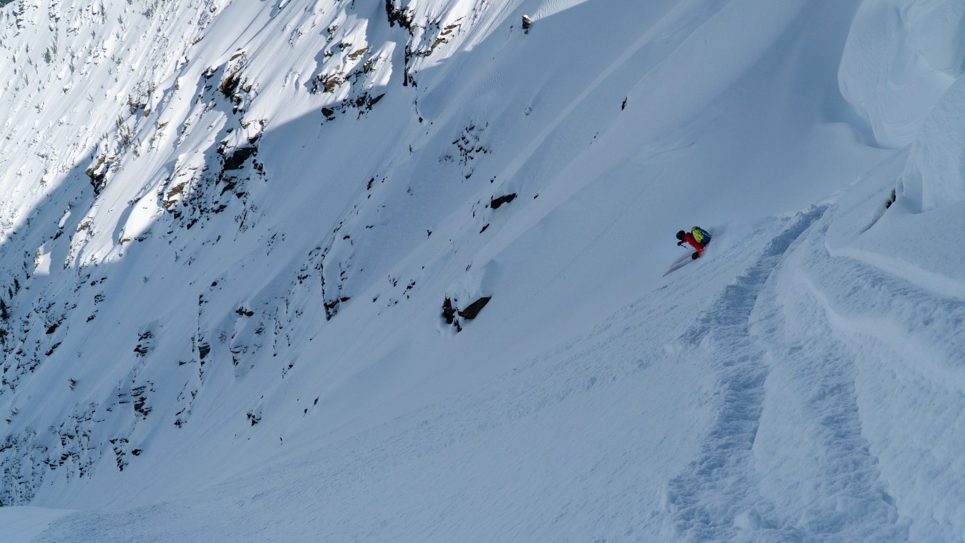
At 2100m, we hurried across the main path, covered in re-frozen chunks of ice after a recent avalanche had ripped through the feature. I had to constantly knock the snow accumulating under my crampons to shed some weight. We eventually reached a bench that split into two gullies We employed the left option as it was sheltered from the steaming SW face to our right, overhead. We transitioned back to skis, drained by the long, trying bootpack, and moved up the steep, narrowing gully. We must have used 40 switchbacks to gain the Green/Ross ridge. It was ridiculous! A friend who headed for Mt Green a day later commented on the aesthetics of my uptrack. After more than 2 hours, we reached the entrance of Cougar Creek West out of the enduring solar hazard.

At our final elevation of 2390m, we scoped out the entrance. Fortunately, the elongated cornice hanging on the lee of the ridge (above our planned descent) smoothed into a gentle roll to the east. Easy! We didn’t need to cut the cornice or rappel down. Freddy put a first ski-cut on the 30° slope, traversing hard-right under the cornices. Nothing would budge, except some minor sluff. I heard his hooting and hollering as he completed a few turns. BLOWER!
We moved quickly, minimizing our time spent under the dense snow/ice formation that might break at any time. A portion of the cornice was still in the sun, weakened by the warming snow. Freddy led the way, cutting above the narrowing couloir and sending some sluff downslope to provide some terrain definition.

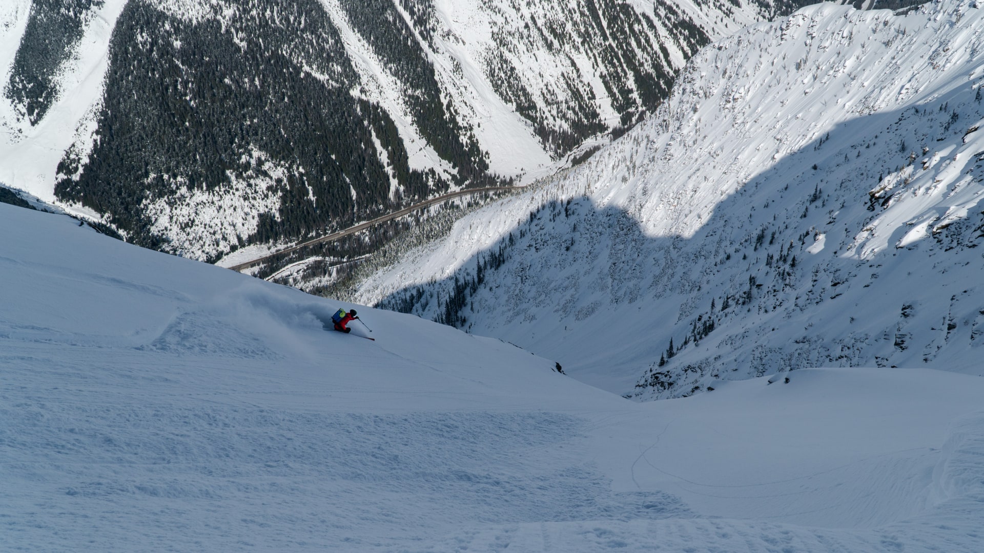
We skied down the couloir that narrowed into a 4m choke. The snow was all-time, providing absolutely no resistance. We charged down the feature with a few short-radius turns and launched into an alpine bowl. Simply amazing! After catching our breath and recognizing our stoked energy, we pressed on through a complex system of gullies that required careful navigation. We played the micro-aspects to avoid a nasty sun crust that had formed below 1600m.

At the bottom of the run, we looked back at our work. What a line! I scrutinized our satisfyingly symmetric turns below the gullies. Our skin was basking in the soft afternoon sun, warming our tired souls. Another one for the books. A party glided past us: they were coming back from skiing the north face of Mt Green, a Rogers Pass classic. We followed an icy uptrack next to the CP rail, heading back to the Loop Brook parking lot where our vehicle was patiently waiting for us.


Route Info
For more beta on my adventures, check out the Route Map. This online map interface is a repository of Beyond Our Peak’s published ski touring and mountaineering routes. It’s the best way to browse through trip reports. Give it a shot!