The west ridge of Pigeon Spire, famous for exhilarating exposure and spectacular views, is hailed as one of North America’s best easy 5th-class alpine climbs. Located within Bugaboo Provincial Park, colloquially known as the Bugaboos or the “Bugs”, the route delivers on spectacular views of arguably British Columbia’s most striking mountain range. From the jagged, granite peaks of the Howser Towers to the uber-exposed crack climbing, this park is a favorite amongst alpine climbers and mountaineers alike. The first thing you notice is the towering spires rising from the crevassed undulations of the vast glaciers. Those spires are made of granite, a rock known for supporting pristine crack systems and excellent traction, heaven for traditional crack climbers. Bring your cams, nuts, and alpine draws because the park doesn’t allow bolted routes except for the occasional anchors where a rappel is mandatory.
Report from July 20, 2020
I spent 3 days in this paradise and summited Crescent Spire (up the Lion’s Way route) and Pigeon Spire (up the west ridge) with scruffy mountain man, Phil Lester. This report covers the latter in great detail.

I woke up at 5 AM with no trouble as it usually is the case when an adventure awaits me. I accidentally kicked Phil in the face, lying across from me in my two-person Black Diamond Eldorado tent. Oops! We cooked a quick oatmeal breakfast and were ready within an hour. By 6 AM, we were already traversing the snow slopes west of the Applebee Dome campground, approached a few days earlier through the Kain Hut trail.
Kain Hut Trailhead Tip
We beelined for the Bugaboo-Snowpatch Col (B-S Col) – you guessed it – nestled between Bugaboo Spire (3204m) and Snowpatch Spire (3084m). The steep 50-degree slope leading up to the col had been known for killing a few climbers. Rockfall from the overhead spires is commonplace and extremely dangerous.

We raced up the slope just as the sun was softening the surface. We couldn’t have nailed the timing more perfectly! In the meantime, we could decipher the repeated, bone-chilling tumbling of rocks on the NW face of Bugaboo Spire. We still donned crampons as we weren’t sure of the conditions in the upper part of the col. It turns out the grade wasn’t as steep as I expected. I’ve climbed way more technical snow slopes in past ski-mountaineering missions.

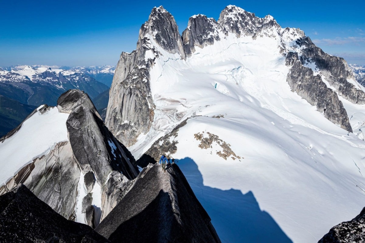
From the col, we caught our breath with no time wasted on the slope below. We hopped on the upper Vowell Glacier, one of the Bugs’ many icefields and followed some existing tracks heading towards the west ridge of Pigeon Spire.

The west ridge of Pigeon Spire grew steeper, as we approached the daunting peak. That’s the tricky thing about perspective in the alpine. Routes always seem impassible from a lower perspective but are always easier when viewed from a higher point. Objectives are also a lot further than you’d think. As for the route itself, the sequence is best explained in the image below.

After about 1 km of glacier travel, we arrived at the base of the west ridge that greeted us with a welcoming sight, the world’s most scenic open-air poop hole. Unfortunately, I felt the sudden urge to relieve myself and forgot to snap a shot of the famous green toilet but let’s not dive too deep in the complex realm of my bowel movements. After a short fourth-class section consisting of a smooth broken-up slab and one tricky bouldering move, Phil and I gained the ridge on which we stayed for most of the ascent.

We felt very vulnerable on that ridge. The fatal drops on both sides kept our heart rates nice and high. I love this feeling, the endless waves of stress and adrenaline when exposed to hazardous climbs. What a blast! We moved fast, unroped, and quickly gained the first of two false summits which provided us with a clear view of what was awaiting. From our angle, the remainder of the ridge seems unusually vertical. This was supposed to be a 4th-class scramble.

As evidence of my earlier comment on perspective, the ridge’s angle laid back as we neared its base. From this point on until the “a-cheval” traverse, the climbing was exceptional with serious exposure and low-fifth-class moves. Two parallel crack systems spanning the section’s length provided secure footing and solid handholds. So good!

We eventually stumbled on the “a-cheval” traverse (commonly misspelled “au-cheval”), a 15m-long, knife-edge ridge that most people cross as if sitting on a saddle with legs dangling on both sides. Phil and I both tip-toed along, trusting the sticky sole of our rock/approach shoes.

We climbed a little more and gained the second false summit with ease. We lowered ourselves down a narrow chimney onto a ledge system extending past the summit of Pigeon Spire, to its left. The ledge was still covered with ice and snow, unseasonal for late July. After debating the facts (slippery conditions, fatal exposure below, time of day), we opted to pitch this one out with the single trad rack we brought and a single 60m half rope. We might as well use it if I lugged it all the way up there.

After struggling with placing gear in snow, the traverse led us to a 5.0 chimney which funnelled us to the base of the 5.4 crux pitch. The climb was technically simple but had a few moves that had us smearing laterally against a smooth slab with a nasty drop below. We choose to simul-climb this one although it could have been completed as a short belayed pitch followed by some unroped scrambling. Moments later, we summited Pigeon Spire through its west ridge. This was a major milestone for me as I was easing myself into the unforgivable world of alpine climbing.

With enough time spent enjoying the summit views, we rappelled down the two 20-25m pitches onto the icy traverse below. This time, we crossed it without belay with the advantage of prior experience. We downclimbed the length of the west ridge where we met a group of two climbers who weren’t quite as comfortable with the exposure, at which point we provided them with reassuring beta. Moments later, we landed back on the Vowell Glacier and made short work of the downhill snowfield with some fun glissades. I was so relieved that no one got hurt!

For safety’s sake, we rappelled down the B-S col. The slopes below strangely weren’t crevassed at all, again, a testimony of the heavy snowfall this past winter. Two rappels later, we glissaded down the remainder of the slope towards the high ground of the Applebee Dome campground.

Statistics
| Campground Approach | Summit Day | |
| Peak Elevation | 2500m | 3156m |
| Vertical Gain/Loss | 1000m | 800m |
| Distance Traveled | 4.5km | 7.0km |
| Duration | 2.5h | 7h |
For more beta on my adventures, check out the Route Map. This map interface is a repository of my ski touring and mountaineering missions. It includes a loose GPS route for your convenience.
Photos


