Earlier in the week, Freddy Lynn and I were contemplating climbing Mt Sir Donald (3284m), one of the highest peaks in the Rogers Pass area. Unfortunately, the previous days’ weather wasn’t on our side. Snow and ice blanketed its northwest ridge, rendering the climb borderline suicidal. And so, we looked across the valley at the Mt Sifton Southeast Ridge, renowned for its excellent quartzite and plentiful jugs. With its lower elevation (2822m), this 4th-class ridge would be dry for the most part. To change things up a bit, we planned to descend the north ridge composed of easier 3rd class terrain. This route would lead us to the Rogers/Sifton Col and, from there, link us to the Hermit Trail.
Related: Rogers Peak Traverse: The Long Haul
Report from September 8, 2020
Kaitlin, Mikey, Freddy and I started the day at a leisurely hour, 8:30 AM, quite unusual for a long mountaineering day. We ran up the 3km of the Hermit Trail, now quite familiar with its relentlessly steep switchbacks. We sped past the Hermit Meadows Campground onto a gentle moraine terminating at the southeast ridge of Mt Sifton.

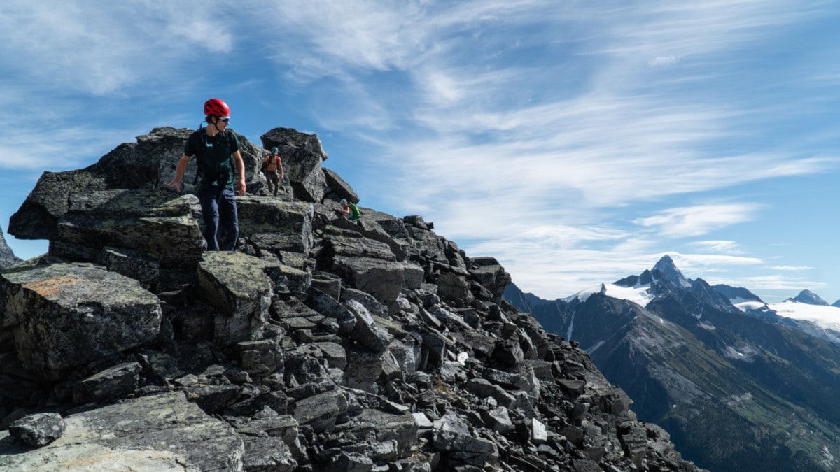
From there, the long scramble began with the lower section featuring sustained 3rd-class climbing. We stuck to the very crest of the ridge throughout most of the climb as it provided the best rock quality. Following either side meant dealing with scree, grass, and choss. Did I mention I absolutely despise scree. I HATE IT – as most mountaineers do.

Midway across the lower ridge, we stumbled across a tilted slab linking two false summits with gnarly exposure on both sides. We crossed the slab with a few hand-to-hand moves on its high side. What a rush! Alternatively, the feature can be avoided to the climber’s left on a series of ledges… but where’s the fun in that!

After an hour of uninterrupted scrambling, we arrived at the base of the 4th-class ridge which I will call the summit tower for our convenience. This section looked step and impassable at first glance. With careful scrutiny, we planned a clean route, zig-zagging up the large blocks of quartzite. Higher up, we would traverse across a grassy ledge to the climber’s left, joining with the 3rd-class southeast buttress. Unless shit hits the fan, this route would be climbed unroped.

The southeast ridge supported some excellent climbing with large jagged flakes, deep cracks, and manageable exposure. As long as we were careful not to cut our hands on the sharp rock, we would be fine. This reminded me of the west ridge of Mt Tupper, albeit at a lower technical difficulty and with much less exposure. I’d recommend short roping this section if uncomfortable.

Midway up the summit tower, we encountered a gendarme blocking our progress. Freddy and Mikey went around to the left through a nasty gully lined with loose dirt and small pebbles. Kaitlin and I went all in. We climbed directly up the gendarme with a few awkward, overhanging 5th-class moves. This particular option is ill-advised for the inexperienced climber as it required a bit of strength.

We gained the top of southeast ridge which later terminated in a loose gully and connected to the north ridge. We choose to traverse left across a grassy ledge onto the southeast buttress. A short 3rd/4th-class scramble across a cracked slab led us to a wide bench, 50 meters short of the summit.

This was the end of the Mt Sifton Southeast Ridge. Technically, we were now standing on its north ridge. We took a well-deserved food and water break while enjoying the clement weather.

Moments later, we were back on our feet, climbing the last few meters to the summit. We followed the base of an old cornice hanging off the Sifton Glacier. At 1 PM, we had reached the summit of Mt Sifton through its southeast ridge. In retrospect, this was a top-quality climb with impressive views and even better rock.

It was now time for the descent of the north ridge, consisting mostly of 3rd class terrain. The lower technical level was welcomed with open arms as downclimbing is always harder on the body and mind. We trailed under small cornices bounding the Sifton Glacier. At this point in the season, they were almost entirely melted, granting us an intricate view of the glacier’s internals.

Once we passed the glacier/cornices, I took a deep breath. Potential icefalls were in the back of my mind the whole time. I peered down the ridge only to spot Freddy paving a way through the blocky quartzite. This guy flows through the mountains with a swiftness that’s unheard of! I looked past Freddy, across the gray valley at Hermit Valley’s highest peak, Rogers Peak, which I traversed from west to east in the summer of 2019 (Rogers Traverse: The Long Haul).

We dropped west of the ridge (climber’s left) and navigated a complex system of rocky ledges marked by cairns until we reached an obvious gendarme. From there, we climbed back up the ridge and dropped on its eastern flank (climber’s right).

I scouted ahead, looking for an easy way out of the east face. While worn footpaths beelined down the face, we stuck to our original plan and circumnavigated the gendarme. Turns out this was a great idea as the terrain below this feature terminated in a large cliff. We slowly forged a path through scree, boulders, and dirt, improvising a trail as we went.

By 6 PM, we had gained the Rogers-Sifton Col. from that location, we descended a heinous scree slope to the head of the Rogers Glacier. We staggered our path: rockfall (high-speed projectiles) was a serious concern here. I’d recommend walking further along the col to the base of Rogers west ridge before dropping down. This would avoid much of the loose scree.
By the time we approached the Hermit Meadows, the sun was setting behind the Hermit Range. What a perfect day!

Photos

The Bonney Range with its heavily crevassed glaciers. Photo: Beyond Our Peak 
The Sir Donald Range. Excellent alpine climbs there. Photo: Beyond Our Peak 
Mikey, navigating the last few meters to the summit of Mt Sifton. Photo: Beyond Our Peak


Statistics
| Peak Elevation | 2922m |
| Vertical Gain/Loss | 1710m |
| Distance Traveled | 11.5km |
| Duration | 12h |
For more beta on my adventures, check out the Route Map. This online map interface is a repository of my ski touring and mountaineering adventures. Simply follow the rough trace!